Surveying
Surveying is the technique, profession, and science of determining the three-dimensional positions of points and the distances and angles between them. These points are then used to create plans/maps for levels and/or feature locations and is fundamental to any land development project.
At Horizon we can undertake any of the following surveying tasks, or anything else you may wish for us to measure.
Topographic Survey
 The starting point for most projects should be a comprehensive and accurate site plan depicting significant features and levels in terms of the relevant datums. It is a piece of vitally important information as such a survey will form the basis of subsequent building and subdivision design work by our team and/or your architect.
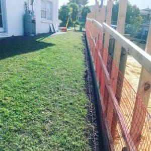
Boundary Marking or Redefinition
As licensed cadastral surveyors we are qualified to mark out your boundary location. Whether you need your fence marked out the boundary for a new fence or to resolve a dispute with your neighbour we are to help. We can also assist with redefining your property if your title is limited as to parcels.
Land Transfer / Cadastral Surveys
This typically forms part of the subdivision process and includes marking out of the new boundaries to create the new lots and preparing the new survey and title plans which form the basis of the new titles. This might also include a boundary adjustment between neighbours.
Easement Surveys
An easement is a right agreed between a landowner and another party to use a property for a particular purpose. A survey plan will be required to depict the area for the said right which is then registered against the title. These easements include rights of way, and rights to protect service connections.
Building Set-Out Certification
Council will typically require that a surveyor certify the location of a new building. From commercial to residential we can set-out a building allowing for quick and easy certification. 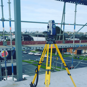
Height in Relation to Boundary Certification
As well as the horizontal position Council will often require the height in relation to boundary be certified by a surveyor. This ensures compliance with the Council planning rules, if we have undertaken the original topographic survey we can rely on this information, if not we will also need to survey the heights along the boundaries.
Levelling and Monitoring Surveys
New Zealand is a country which is always moving, some of our land is susceptible to subsidence, as a result it often critical to undertake levelling or monitoring surveys to record any movement during the construction or even deconstruction of a building or project.
As-builts Surveys
Data is a very valuable asset and it is therefore important that we accurately record the position of new assets once they have built. This type of survey is typically used to record new infrastructure such as roads and pipes.
Cross Lease and Unit Title Surveys
A Cross-Lease was a form of subdivision popular in the 1970’s and 1980’s. It, unfortunately, has its pitfalls. We can assist with updating your cross lease or alternatively we can help you convert it to a fee simple title and increasing the value of your property.
Unit Titles are still commonly used today and if a fee simple subdivision is not an option then we can prepare a unit title subdivision plan for you.
Aerial Surveying (UAV)
Our UAV(Drone) is a great way to complete large topographic surveys or in short space of time. Utilising aerial photographic we can provide a 3d model for concept design.